


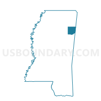
Nettleton Voting District, Monroe County, Mississippi
About
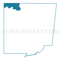
Outline

Summary
| Unique Area Identifier | 606285 |
| Name | Nettleton Voting District |
| County | Monroe County |
| State | Mississippi |
| Area (square miles) | 24.99 |
| Land Area (square miles) | 24.98 |
| Water Area (square miles) | 0.01 |
| % of Land Area | 99.98 |
| % of Water Area | 0.02 |
| Latitude of the Internal Point | 34.07081570 |
| Longtitude of the Internal Point | -88.63238960 |
Maps

Graphs
Select a template below for downloading or customizing gragh for Nettleton Voting District, Monroe County, Mississippi


Neighbors
Neighoring Voting District (by Name) Neighboring Voting District on the Map
- Bigbee 1 Voting District, Monroe County, MS
- Boyds Voting District, Monroe County, MS
- Central Grove Voting District, Monroe County, MS
- Nettleton Voting District, Lee County, MS
- North Okolona Voting District, Chickasaw County, MS
- Pleasant Grove Voting District, Lee County, MS
- Shannon Voting District, Lee County, MS
- Wren Voting District, Monroe County, MS
Top 10 Neighboring County Subdivision (by Population) Neighboring County Subdivision on the Map
- District 5, Lee County, MS (15,115)
- District 4, Lee County, MS (14,271)
- District 1, Monroe County, MS (8,172)
- District 5, Monroe County, MS (7,440)
- District 3, Chickasaw County, MS (3,429)
Top 10 Neighboring Place (by Population) Neighboring Place on the Map
Top 10 Neighboring Unified School District (by Population) Neighboring Unified School District on the Map
- Lee County School District, MS (37,543)
- Amory School District, MS (9,652)
- Nettleton School District, MS (6,845)
- Okolona Separate School District, MS (5,210)
Top 10 Neighboring State Legislative District Lower Chamber (by Population) Neighboring State Legislative District Lower Chamber on the Map
- State House District 17, MS (25,981)
- State House District 21, MS (23,452)
- State House District 16, MS (22,500)
- State House District 36, MS (21,886)
- State House District 22, MS (21,435)
Top 10 Neighboring State Legislative District Upper Chamber (by Population) Neighboring State Legislative District Upper Chamber on the Map
Top 10 Neighboring 111th Congressional District (by Population) Neighboring 111th Congressional District on the Map
Top 10 Neighboring Census Tract (by Population) Neighboring Census Tract on the Map
- Census Tract 9502, Monroe County, MS (7,366)
- Census Tract 9511, Lee County, MS (6,517)
- Census Tract 9501, Chickasaw County, MS (4,110)